


Mad Mutt Marine GPS Navigator

توضیحات Mad Mutt Marine GPS Navigator
I started writing this application as something that would be useful to me. Since that it has grown and I am rather pleased with it. It is an aid to marine navigation and must be used in conjunction with charts that are printed on that white stuff that is called (So I’m told) paper.
Features
•Designed by and for a sailor. You may find that some of the layouts look “big and blobby” at first sight, but they work at sea. Fiddly and fussy layouts do not.
•No network required. This app uses your phone’s GPS, it will work where there is no mobile network coverage (though you will need network coverage to share your logs and waypoints by email).
•Store unlimited waypoints (restricted in free version).
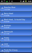
•View waypoints alphabetically of by distance from your current position.
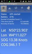
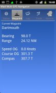
•Display range and bearing to a waypoint.
•Make logs of where you have been, which you can annotate with comments and other relevant data.
•View logs as display on the phone.
•Share logs with Google Earth on your phone or desktop computer, either by email or by copying KML files.
•Share waypoints with Google Earth on your phone or desktop computer, either by email or by copying KML files.
•Share logs with Google Earth on your phone or desktop computer, either by email or by copying KML files. Although I don’t encourage the use of Google Earth for marine navigation, seeing your waypoints on Google Earth is a useful visual check that you have transcribed them correctly.
•Anchor watch alarm service. Alerts you if you have moved more than a pre-defined distance. The anchor watch also alerts you if the battery level is low.
•Near waypoint alarm service
•Once started, the log, anchor and waypoint alarm services will continue to run, even if you quit the main navigator application. They will continue to run while you make phone calls or use your phone for email, Internet browsing or pretty much anything else.
What this application is not
It is not a chart plotter. This application is intended for marine navigation. Although it could be used by ramblers, that isn’t the main intention. It does not display digitised charts, nor does it show you a Google Map view with your position displayed on it. I believe it is highly irresponsible to encourage the use of Google maps to navigate boats. Even in rivers and estuaries, Google maps contain no semantics for the sea whatsoever; no lights and marks, depths, rocks etc. The application does allow you to send logs you have made to Google Maps, though, but only after you have completed the trip.
Free Version
For a limited time, a free version is available. In the Autumn of 2012 a full feature version should be available.
The free version has the following limitations:
•The number of waypoints you can have is restricted to 20.
•Routes are not available
</div> <div jsname="WJz9Hc" style="display:none">Ik begon te schrijven deze toepassing als iets dat nuttig voor mij zou zijn. Sindsdien is het gegroeid en ik ben nogal blij mee. Het is een hulpmiddel voor de zeevaart en moet worden gebruikt in combinatie met grafieken die zijn afgedrukt op dat witte spul dat heet (is me verteld) papier.
Functies
• Ontworpen door en voor een zeeman. Het kan zijn dat een deel van de lay-outs kijken "grote en blobby" op het eerste gezicht, maar ze werken op zee. Onhandig en pietluttig layouts niet.
• Geen netwerk vereist. Deze app maakt gebruik van GPS van uw telefoon, zal het werken wanneer er geen mobiele netwerkdekking (al zul je netwerkdekking nodig hebt om je logs en waypoints te delen via e-mail).
• Bewaar onbeperkt waypoints (beperkt in de gratis versie).
• Toon waypoints alfabetisch van op afstand vanaf uw huidige positie.
• Display bereik en de peiling naar een waypoint.
• Zorg logs van waar je bent geweest, die u kunt noteren met commentaar en andere relevante gegevens.
• Logboek als display van de telefoon.
• Deel logs met Google Earth op uw telefoon of desktop computer, hetzij per e-mail of door het kopiëren van KML-bestanden.
• Deel waypoints met Google Earth op uw telefoon of desktop computer, hetzij per e-mail of door het kopiëren van KML-bestanden.
• Deel logs met Google Earth op uw telefoon of desktop computer, hetzij per e-mail of door het kopiëren van KML-bestanden. Hoewel ik niet het gebruik van Google Earth voor de zeevaart aan te moedigen, het zien van uw waypoints op Google Earth is een handige visuele controle dat je ze correct getranscribeerd.
• Ankerwacht alarmdienst. Waarschuwt u als u meer dan een vooraf bepaalde afstand zijn verhuisd. Het anker horloge waarschuwt u ook als de batterij bijna leeg is.
• In de buurt waypoint alarm dienst
• Eenmaal begonnen, zal de log, anker en waypoint alarm diensten blijven draaien, zelfs als u de belangrijkste navigator programma te stoppen. Ze zullen blijven draaien terwijl je telefoon bellen of gebruik maken van uw telefoon voor e-mail, surfen op internet of vrijwel niets anders.
Wat deze toepassing is niet
Het is niet een kaartplotter. Deze applicatie is bedoeld voor de zeevaart. Hoewel het kan worden gebruikt door wandelaars, dat is niet de belangrijkste bedoeling. Het maakt niet gedigitaliseerd grafieken weergegeven, en geeft evenmin aan u een Google Map view met uw positie weergegeven op het. Ik vind het zeer onverantwoord om het gebruik van Google maps aan te moedigen om boten te navigeren. Zelfs in rivieren en estuaria, Google maps bevatten geen semantiek voor de zee dan ook; geen verlichting en merken, diepten, rotsen etc. De toepassing doet kun je logs je naar Google Maps, hoewel, maar pas nadat u de reis hebt voltooid hebben gemaakt sturen.
Gratis Versie
Voor een beperkte tijd, een gratis versie beschikbaar is. In het najaar van 2012 moet een volledige functie-versie beschikbaar zijn.
De gratis versie heeft de volgende beperkingen:
• Het aantal waypoints die je kunt hebben is beperkt tot 20.
• Routes zijn niet beschikbaar</div> <div class="show-more-end">
Mad Mutt Marine GPS Navigator - نسخه 1.06
(24-07-2013)
Mad Mutt Marine GPS Navigator - اطلاعات APK
نسخه APK: 1.06حزمة: uk.ac.plymouth.madmutt.gpsnavigatorآخرین نسخه Mad Mutt Marine GPS Navigator


 3.78
3.78


اپلیکیشنها در دسته مشابه

شاید دوست داشته باشید...


